- 7 August 2016
- Latin America & Caribbean
출처: http://www.bbc.com/news/world-latin-america-36884261
Following Columbus: The team trying to rewrite the explorer's route
 JON NICKSON/EYESPICE.COM
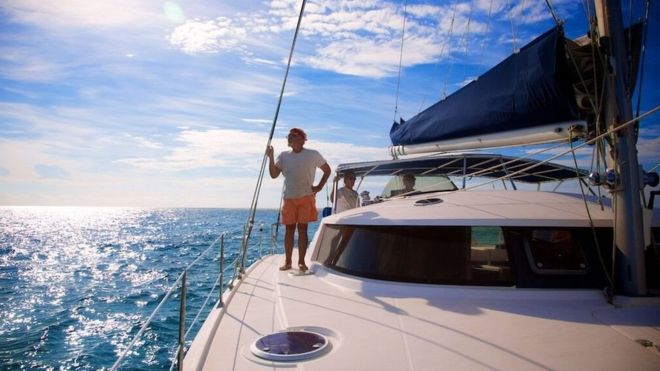
More than 500 years after Christopher Columbus made his first fateful landfall in the New World, modern day adventurers from Turks and Caicos are retracing his route on a quest to rewrite history.
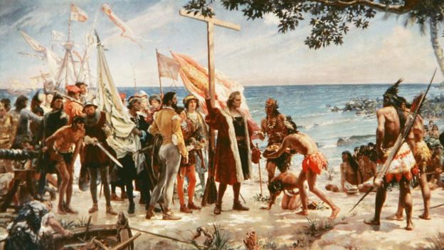
The Italian explorer's momentous transatlantic voyage in 1492 saw the meeting of two hemispheres for the first time since the Vikings - a feat that would change the course of history forever.
 AFP
AFPBut precisely where he initially set foot has been disputed for centuries, with as many as 10 islands across the Bahamas and Turks and Caicos (TCI) claiming the accolade.
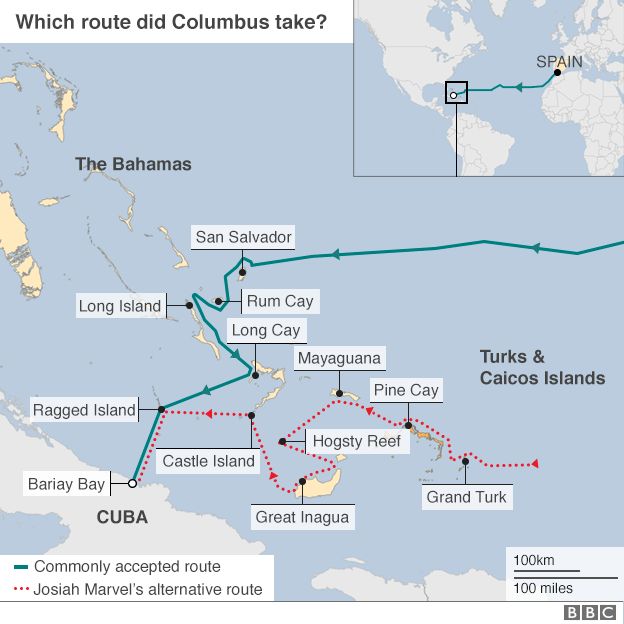
Now a team of sailors and a historian have made it their mission through a series of maritime expeditions to prove that Columbus' arrival in the Americas was on Grand Turk, TCI's capital isle.
While their theory may not be popular among Bahamians who have long claimed San Salvador as the historic site, they say they want to "set the history books straight".
If successful, it could also be an enormous tourism boost to the tiny British territory.
Devil in the detail
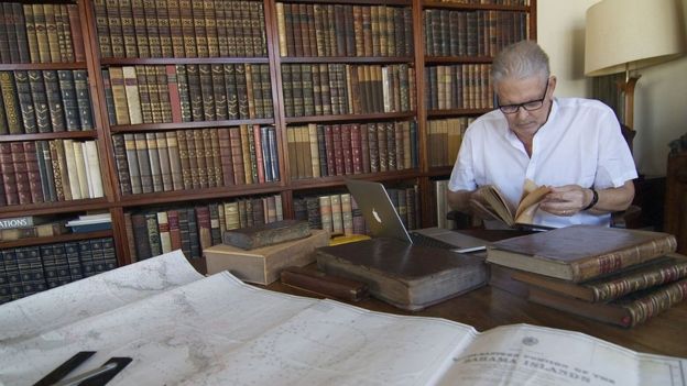
Historian and long-time TCI resident Josiah Marvel has spent three decades scrutinising age-old texts detailing Columbus' voyage in libraries across the globe.
 OLIVIA SAVOURE
He has even created his own translations of Columbus' diary, accounting for mediaeval grammar and nautical phraseology.
Mr Marvel claims other modern translations have "too many flaws" to justify the long-held assertion that San Salvador, known as Watlings Island until 1926, was the landfall spot.
Among them is the failure to allow for magnetic variation - causing misreadings in Columbus' compasses - and the apparent impossibility of various moorings.
Additionally, Columbus' diary gives latitudes indicating the difference between the landfall island and Hispaniola to be 90 nautical miles.
"Almost the precise distance between Grand Turk and Hispaniola," Mr Marvel said.
To test the theory, he joined forces with two professional sea captains to sail an alternative route from Grand Turk to Ragged Island - Columbus' final stop in the Bahamas - via Mayaguana and the Inagua Islands.
'Fascinating puzzle'
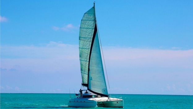
The trio's first trip aboard catamaran Destiny II, which they say has speeds equivalent to Columbus' Santa Maria, set sail in November 2014.
 JON NICKSON/EYESPICE.COM
Captaining the voyage was veteran Bahamian sailor Dave Calvert, who helped set a transatlantic crossing record in 2001.
"After becoming acquainted with Josiah's work, I do believe his theory is the most accurate," Mr Calvert told the BBC.
Expedition leader Tim Ainley said "clues" in Columbus' diary create a "fascinating puzzle which has enthralled historians and mariners for centuries".
 JON NICKSON/EYESPICE.COM
"The text is vague because in those days they didn't have GPS, they didn't know how to calculate longitude and Columbus' fleet was completely lost - they thought they were heading for Japan," Mr Ainley explained.
Mr Ainley, who has 30 years' experience sailing the region's waters, continued: "Everybody agrees Columbus was a consummate mariner. His ships could not sail towards the wind so they would have been very careful about how they were going to sail back out of somewhere before they sailed in.
"Neither did they have anchor chains, so would have needed a clear sandy bottom to drop a rope-secured anchor in. This very much limits the anchorages.
 JON NICKSON/EYESPICE.COM
"Also, magnetic variation meant Columbus thought he was heading west but in fact was heading further south than he realised. This ties in perfectly with Grand Turk which is the southernmost island of all the possible landfall places."
Perfect alignment
The last leg of the 2014 expedition was plagued by calm weather, prompting a follow-up trip last December.
After completing their route, the team is convinced it aligns precisely with the diary's clues.
This time the members were joined by US archaeologist Shaun Sullivan to search for evidence of a Lucayan settlement on Mayaguana, where the crew believe Columbus was when he reported being surrounded by Lucayans in canoes.
 JON NICKSON/EYESPICE.COM
"It's absolutely clear that Columbus landed somewhere in the south-eastern Bahamas or Turks and Caicos - but exactly where remains an open question," Dr Sullivan said, adding that resolving the issue would require "a long, scholarly process" and the accumulation of additional physical evidence.
The men are now gearing up for a third voyage this autumn re-enacting Columbus' commonly accepted route from San Salvador to Ragged Island - with the explorer's logbook in hand - in an effort to prove the distances and directions do not fit the text as accurately as a departure from Grand Turk.
"I want to set the history books straight and prove once and for all that we know he landed in Grand Turk.
"To our knowledge, no other historian has ever sailed the various alternative routes through the southern Bahamas and TCI," Mr Ainley added.
"Personally, I find it fascinating. It gives me goose bumps to think I am literally sailing in the wake of Columbus' fleet from all those years ago."
'국제문제 > 남미' 카테고리의 다른 글
| (남미/브라질) 브라질의 탄핵당한 女대통령 루세프와 관련된 몇 가지 중요한 질문 (0) | 2016.09.01 |
|---|---|
| (남미/브라질) 브라질에서 유행하는 힙업 성형수술 (0) | 2016.08.09 |
| (남미/브라질) 리오 올림픽 개막식에서 보여준 따뜻함, 열정, 희망의 메시지 (0) | 2016.08.07 |
| (남미) 파나마정부 1989년 미군의 파나마침공에 대해 진상조사 시작한다 (0) | 2016.08.01 |
| (남미) 콜롬비아 의회 자주 무단결석 하는 의원들의 봉급 깎는 법안 발의 (0) | 2016.06.17 |